Julian’s Blog

Julian connects with earth scientists and educators in New Zealand and overseas

10 Highlights from a trip to Antarctica

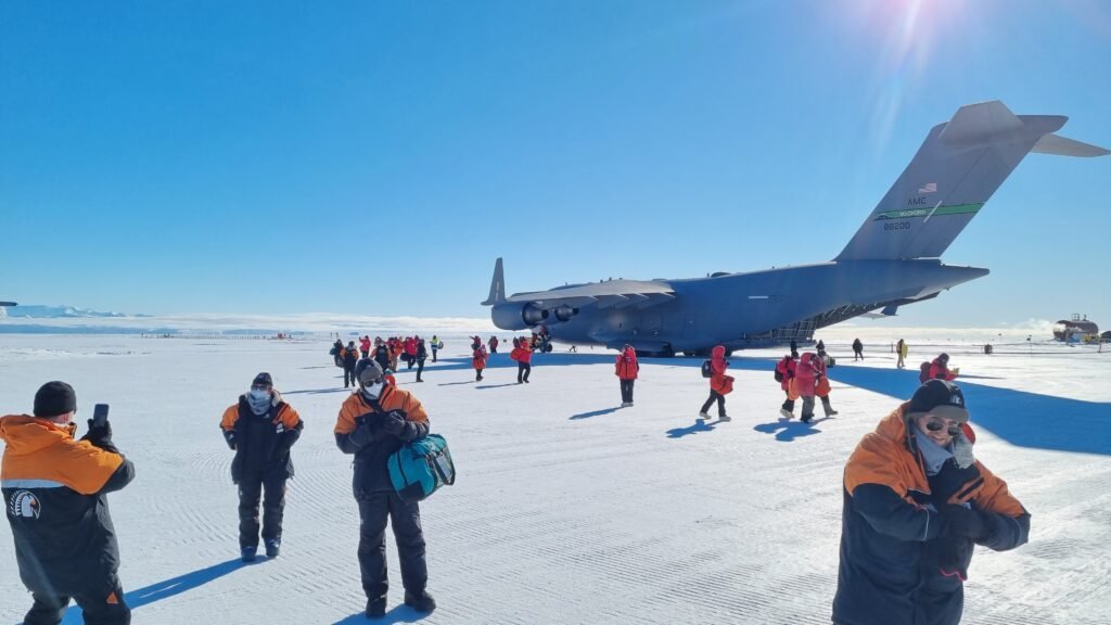
10 Highlights from a trip to Antarctica By Julian Thomson Recently I returned from about 6 weeks in Antarctica, assisting a science team researching the microbes that live within the sea ice. We were based near Scott Base, and I was privileged to have time to learn about the science and explore some of the local landforms around McMurdo. Here are 10 highlights from the experience: 1. The FlightApart from the impressive experience of flying on a huge C17 military plane, the views looking down to the unfolding icy wilderness of Antarctica are mesmerizing. Mountain ranges, glaciers, frozen ocean and eventually Ross Island as we closed in on the McMurdo Ice Shelf, our landing field. The landscape is totally devoid of human structures, roads or houses – a truly empty wilderness 2. Scott BaseScott Base is a staging point for many New Zealand science expeditons that fly or drive out to their field sites on Ross Island, the Ice Shelf or the Transantarctic Mountains. Scott Base is an experience all of its own – You are looked after by a dedicated and high functioning group of specialists who look after the infrastructure, the machinery, the food,  the domestic services, the field equipment and your safety whilst down on the ice. Whilst at the base you can venture out for various walks, go mountain biking and cross country skiing, or visit the much larger US McMurdo Station about 3kms away. 3. The TeamScience expeditions to Antarctica are limited due to the cost and logistics of travelling there and undertaking field work in such a remote and difficult environment. Science teams are usual small groups of a handful of people with different skill-sets. You are bunched together in a close knit group for weeks at a time and get to know each other’s strengths and weaknesses quickly and intensely. There is a strong sense of shared privilege and awe at being able to participate in such a life changing experience. 4. The CampThe personal gear and camp equipment is super rugged as you would expect, as it has to keep you warm in extreme low temperatures and high winds. Apart from being tough for wear and tear, the principle of layering is key – you add or take away layers to adjust to the fluctuations of temperature through the day. Because the equipment is so good you can easily overheat when at work, but similarly you can get cold really quickly, for example if you take your gloves off to do a fiddly task or if some of your face is exposed when travelling on a skidoo. All the clothing you need is supplied for you and fitted before you leave New Zealand, whilst all camp gear is distributed out of the field equipment store at Scott Base. 5. The Science Research: Our research project was led by Andrew Martin of Victoria University of Wellington, Te Herenga Waka. We were investigating rhodopsin proteins that form part of the cell membranes in sea ice bacteria. They have the ability to use energy from sunlight in a way that is quite new to science. This video gives an idea of  some of the fieldwork we undertook: https://youtu.be/t9oALdSBrqE 6. Sea IceUp to 18 million square kilometres of the ocean around Antarctica freezes and then melts every year. This sea ice develops to about 1 or 2m thick. It is actually quite variable and not all of it melts so that some of it is multi-year ice.The process of sea ice formation goes through several stages, which gradually dampen down the waves until a flat uniform sheet of sea ice can develop: Frazil ice is the initial stage  in which tiny, small, flat, plate-like ice crystals form in the water. This typically happens when the ocean temperature drops below freezing point, and can occur in a matter of minutes to hours. Grease ice is the next stage, where the frazil ice crystals aggregate to form a soupy mixture of ice and water.  Pancake ice is the stage where the grease ice has formed into circular disks with raised rims, called pancakes. These pancakes can range in size from a few centimeters to several meters, and typically form within days to weeks. As they develop they have the effect of flattening out the waves which stablises the sea surface and allows them to start stick together. Stable sea ice is the final stage of sea ice formation, and occurs when the pancakes have grown and fused together. Once this happens the ice quickly thickens and becomes a smooth sheet of sea ice, growing by addition of snow on the top and freezing of sea water below. The weather conditions, such as air and ocean temperature, wind and ocean currents, all affect the rate of ice formation. Another thing to note is that as sea water freezes it squeezes out the salt which becomes concentrated brine at the base of the sea ice as well as in channels trapped within it. This video will give you some idea about sea ice and also the underlayer of platelet ice that can develop: https://youtu.be/Q416Zl8WbpY 7. WildlifeThere is not much wildlife at all in the depths of Antarctica, but in the coastal regions such as McMurdo Sound there are seals, penguins, skuas (a type of scavenging sea bird) that survive on the marine food chain starting with the microbial life in the sea ice and water. Around Scott Base the Weddel seals are the most obvious large animals and they are easily seen and photographed just outside the base. Penguin colonies occur a bit of a distance away and occasional travelling penguins turn up near to the base too. 8. The GeologyScott Base is on Ross Island which is part of the complex of volcanic peaks around Mount Erebus. It is separated from the mainland of Antarctica and the Transantarctic Mountains by McMurdo Sound. Here is a short video about the geology immediately around Scott Base which is built on a lava

10 Highlights from a trip to Antarctica Read More »

How should you best communicate your geoscience research?

How should you best communicate your geoscience research? This article is based on a presentation I gave to the 2020 conference of the Geosciences Society of New Zealand. It is aimed at researchers and aspiring science communicators.  I have been a full time geoscience educator for 14 years, working for GNS Science, New Zealand’s government geoscience research institute, and more recently for myself as the company owner of Out There Learning. This was after a similar amount of time as a Waldorf high school teacher involved with earth and biological sciences, along with lots of outdoor education, curriculum development, teacher training and other activities. In this post I will summarise a few ideas for those earth scientists and educators who may be trying to work out the most suitable ways to communicate geoscience research to non-specialists such as the public, schools etc. You may think of this as public engagement, educational outreach or science communication depending on your intentions and your mode. I use these various terms a bit interchangeably, the main point being that you want to evoke some sort of interested response from an audience around the scientific discovery process. Scope The ideas presented here are my own, based on personal experience of many years as an education and science outreach professional. I have experience with a wide variety of approaches for engaging different audiences. However, there are still options that I have little experience with, and my personal experiences and skill sets have strongly influenced my modes of operation. I haven’t included anything about Citizen Science, Gaming, Podcasts etc, each of which will offer huge possibilities for connecting your science with the public. Therefore these ideas are a point of departure to help you consider your own possible options. What is your goal? So to start with there are a few fundamental questions to consider. For example is your goal  to promote your project? to recruit students to your courses? to help change public perceptions and attitudes? to encourage specific behaviours, eg around geohazards, climate change etc? to share your enthusiasm with no utilitarian goal other than for the love of enthusing others? Information sharing is relatively easy, but trying to change attitudes and behaviours requires an educational approach at a deeper level. So another way we could look at this point is to ask: What level of impact are you hoping to have with your audiences? “Concepts are end points, feelings are actions yet to be taken” Here are three levels that audiences may receive and internalise what you have to share with them. The depth of engagement increases significantly down the levels from 1 to 3. Informational -We want the audience to know or be aware of something. This is on the information or intellectual understanding level. Emotional – We want them to feel something. In other words we hope to arouse emotions associated with what we are showing people. Motivational – We want them to do something.  This may involve a deep cognitive shift that goes right through the intellectual and emotional levels, transforms the way someone perceives the world and leads to inspired action. So think about the level of engagement you want to work on. I would suggest that most scientists intuitively want to go deeper than just the information sharing level, and reach into the feelings of their audiences, to inspire and fascinate them, and perhaps even to engage with them to the point where they feel awakened and empowered to take positive action in some way. Underlying all scientific questions is a human desire of some sort. Any question presupposes that the inquirer has a wish to find something out. In other words, there is an emotional driver underlying all scientific research. Because this is often only appreciated in a vague way, many scientists and teachers focus on giving people information and concepts  and leave the most significant part of the educational process to chance – ie the importance of arousing fascination, interest and relatability- the positive emotional drivers that will ensure that your audiences go away inspired, connected and having their own questions awakened.  Know what works for you If you are someone who feels camera shy, then videos might not be the best choice for your communication activity, but writing texts or creating great photos might suit you well.  So from your perspective, what is the low hanging fruit that will help you get moving with your science communication plan? Consider your options from the stand point of efficiency, given that your situation will include easier and more difficult possibilities: Your preferred audiences and their needs Your team’s unique communication skill sets and preferences The availability of help that you may need Established relationships that you can build on – eg with iwi, museums, community groups or particular schools etc Your short or long term aim which may influence the time and effort you want to invest in developing your approach If you are running a short term project (say 1 to 3 years) your approach might be quite different from that of a department or large programme with a long term (eg 5 + years) view. Know what works for your audience It should be obvious, but it is most important to be highly aware of the interests and needs of your audience if you want to engage with them in a meaningful way.  Find this out through meetings or conversations before you develop your engagement activities. You also need to be prepared to adapt your attitudes, communication style and understandings if you want to be relatable and actually useful: Whose problem are you trying to solve and how will you be solving it? What do people want to learn about that you may know? What are the cultural attitudes and sensitivities of your audience that you should show respect for, and how will you do that? How will you make your engagement or content interesting and relatable for them? Will you ‘deliver’ in a one way manner, or rather

How should you best communicate your geoscience research? Read More »

What’s on our Plates?

Researching tsunami deposits on the East Coast

New Zealand has thousands of active faults each of which will produce an earthquake of some magnitude when it ruptures. However the two giants are the Alpine Fault and the Hikurangi Subduction Fault. They each form a segment of the plate boundary – the Alpine Fault can be traced across land, the length of the South Island, whilst the Hikurangi Subduction Fault is lying in wait under the Eastern part of the North Island, with its surface trace hidden deep underwater along the bed of the Hikurangi Trough and Kermadec Trench. Kekerengu Fault rupture in Nov 2016 (J.Thomson / GNS) Each of these plate boundary faults is capable of causing a massive earthquake greater than magnitude 8, thereby wreaking major destruction and disruption across New Zealand. It makes sense then that a lot of research effort is going in to understanding the past history of these faults. This allows us to gain insight into the probabilities of future ruptures and the sorts of impacts that could occur when one or the other of them next produces a big ‘quake. It also makes sense that if you are living in New Zealand, you should be interested in learning about how the scientists go about their research and what they have been discovering! What’s On Our Plates? is a set of free multimedia learning modules designed to enable anyone to explore Aotearoa New Zealand’s active plate boundary online, including the Alpine Fault and Hikurangi Subduction Zone. The modules are for any interested non specialist who would like to know more about out Plate Boundary research, but they also include notes for teachers who would like to use them as an educational resource. So get ready to dig in to the fascinating story of our two colliding tectonic plates. You can access the modules here.   The resource has been created by a collaboration of AF8 (Alpine Fault Magnitude 8) and East Coast LAB (Life At the Boundary). AF8 is undertaking a comprehensive study of the impacts a rupture of the Alpine Fault would have on infrastructure and the people living in communities across the South Island. It is a collaboration between the South Island Civil Defence Emergency Management (CDEM) groups and scientists from six universities and Crown Research Institutes, emergency services, lifelines, iwi, health authorities and many other partner agencies. The programme is managed by Emergency Management Southland. East Coast LAB (Life at the Boundary) is also a collaborative programme. It brings together scientists, emergency managers, experts and stakeholders across the East Coast to help us better understand and prepare for the natural hazards such as earthquakes and tsunami that may affect us. https://youtu.be/L8UXkQmbHZw

What’s on our Plates? Read More »

Raised Beaches at Tora

Raised beach ridges at Tora

Tora is a small rural community on the Wairarapa Coast of the North Island of New Zealand. There are many interesting geological outcrops and landforms in the area. For me the most spectacular of these are in the area of sloping farmland just south of where the inland road meets the coast. On a recent trip to the area to scope out some school field trips (which were unfortunately cancelled due to the Covid-19 lockdown) I was able to take some images from the air with my drone. They show a series of light and dark parallel stripes running between the shoreline and the steep hillside about 200 to 300 metres inland. The light coloured stripes are ridges, with hollows in between that are picked out by the darker coloured swampy vegetation. These ridges were formed during storms along the beach, when large waves heaped up the rocks into a storm ridge just above high tide level. The reason there are several ridges in a sequence is that earthquakes have pushed up the land periodically, causing the active ridge to become isolated above shore level as the sea retreated to start creating a new ridge. This means that the oldest ridge is furthest inland, up against the hillside and the youngest ridge is presently active along the shore. There are at least 6 abandoned ridges that can be identified, with a seventh in the making at the top of the present day beach. Between the ridges are areas of low lying land that drains poorly, hence the swamp plants within these hollows. It is believed that the sea was up against the hill slopes about 7,000 years ago so that tells us that there is very roughly one earthquake uplift event every 1000 years. The fault responsible for these uplifted beach ridges (the Palliser-Kaiwhata fault) is about 5 to 8 km offshore and is about 60km long.It is a reverse fault where the west side (landward side) thrusts up and over the eastern (seaward) side. Kate Clark of GNS Science sent me this LIDAR image of the area which shows the uplifted beach ridges really clearly. LIDAR is a 3D laser scanning technique that creates images that exclude the vegetation cover and therefore show up the ground surface in incredible detail. The image shows the shoreline from lower left to upper right with the lines of the raised beach ridges between the sea and the prominent hills. Here is a short video I made to explain these features that you may be interested in checking out:

Raised Beaches at Tora Read More »

Where to explore the Wellington Fault

Wellington Fault at Thorndon

The Wellington Fault is one of several large active faults in the lower North Island of New Zealand. From the Tararua Mountains and Kaitoke it runs the length of the Hutt Valley, the edge of Wellington Harbour, through Tinakori in the City and across the hills to Cook Strait. Earthquakes occur on the Wellington Fault approximately every 700 to 1000 years on average, with the last between 170 and 370 years ago. The probability of a rupture in the next 100 years is calculated to be about 10%. Because it runs along the highly populated Hutt Valley and right through the Capital City via its transport bottleneck, it is regarded as one of the country’s highest risk faults. You can find out information about all of New Zealand’s known active faults on the GNS Science Active Faults Database, but in this image you can see a screen grab of those known in the Wellington area, some of them labelled: As you can see there are many other faults in the region, each of which is capable of rupturing, so that the real possibility of a large earthquake occurring at some point from one or other of the faults is something that should inspire everyone to be prepared. (Make some time to go to https://getready.govt.nz/ ) As you can see there are many other faults in the region, each of which is capable of rupturing, so that the real possibility of a large earthquake occurring at some point from one or other of the faults is something that should inspire everyone to be prepared. (Make some time to go to https://getready.govt.nz/ to get the best information on how to do this.) Here is an aerial view of the Wellington Fault trace (bottom right to centre top of the photo) passing through California Park in Upper Hutt and along the centre of  California Drive beyond In neighbouring Harcourt Park, the fault crosses a flight of river terraces at a right angle. This allows us to see clearly that the slip (movements) on the fault are mostly horizontal with some vertical movement as well. Looking across the fault the opposite side moves to the right. This means that the fault is a “dextral oblique slip fault”.   This diagram shows how the Harcourt Park River Terraces are offset by the Wellington Fault The fault can be followed along the Hutt River. In Lower Hutt it runs right along the side of Hutt Road, and into Petone. This photo shows the fault scarp at the end of Te Mome Road where it meets Hutt Road at a T junction:   The entrance to Wellington City at Thorndon is a bottleneck, where the Wellington Fault passes underneath the railway, State Highway and Ferry Terminal, as well as the water supply. This makes Wellington vulnerable to being cut off by a rupture of the Wellington Fault. You can learn more by visiting the Wellington Fault at several points from Upper Hutt to Wellington. Check out this video for details:  

Where to explore the Wellington Fault Read More »

Geology of Bitou, Lailai and Beiguan, Taiwan

Bitou – this small fishing village is about 70km north of Yilan City. Right next to it is the Bitou Geopark. Here you can take a clifftop walk above steep sandstone cliffs, or descend to the shore platform to see some strange mushroom like features at close quarters Here the shore platform is festooned with these strange mushroom shaped concretions. They really are unusual, and make this a famous geological location in Taiwan. As you can see it is also a popular spot for fishing. Due to storms and occasional freak waves there are many accidents all along this coast where people get swept into the sea. Our next stop was the well known shore platform at Lailai. Here the gently dipping sedimentary beds have been folded and faulted. with hard layers of sandstone being less easily eroded (and therefore sticking out more) than the more easily etched out softer mudstones. The shore platform is impressive, with the tilted sedimentary rocks folded into gentle curves, and a lot of faults cutting through the layers. It was a perfect area to use my drone to get these aerial images. A short distance away there is a dyke (an igneous intrusion that originally pushed into the sedimentary rocks as hot magma)  that can be soon cutting through the sedimentary layers of the shore platform. It stands out because it is made of harder rock than the surrounding sediments, and is therefore more resistant to being eroded. Here you can see the dyke is offset – sometimes by faults but also simply by the magma pushing up through slightly different pathways in the original country rock. You can see here how the dyke has baked the adjacent mudstone – giving it a darker colour for about 40cm  to either side of the once hot dyke. A closer view of the dyke standing up like a man-made wall on the shore platform. The baked sediments right next to it have also been hardened by the heating process, so they have also resisted erosion more than the softer surrounding rocks. This video shows a bit more detail of the rocks of Lailai ,which I think is an ideal place to run a geological field trip: Finally on our way back to Dongshan, we stopped in the small Beiguan Tidal Park where you can see these rocks with impressive joints forming a diamond checkerboard pattern. In the background is Turtle Island, another well known local feature.

Geology of Bitou, Lailai and Beiguan, Taiwan Read More »

Geology on the Yilan Coast, Taiwan

To find worthwhile locations that offer great learning opportunities in geology, you have to spend time exploring outcrops, trying to make sense of the geological features that are exposed and then think of ways that students can explore and make sense of them out of their own activity. This inquiry learning process can work well via guided questions that encourage careful exploration and observation and then the unfolding of ideas and understanding. however it doesn’t usually just happen by magic – it takes some working out to frame interesting learning activities at a given unique location. With a small group of teachers from CiXin School, we explored several locations along the coast north and south of Yilan. Heading South we went to a coastal fishing settlement called Feniaolin. Here there were some amphibolites (metamorphic rocks) that are part of a long outcrop extending further south. These are amongst the oldest rocks in Taiwan and have been exhumed from many kilometres deep in the earth’s crust. Just past the fishing wharf there is an area of sea stacks – classic coastal erosion features: We continued further south to the Nanao Valley where there is a mixture of rocks on the river bed including many huge boulders. Some of the boulders were granites (that were once molten magma deep in the earth). They had lumps of schist included in them – fragments of the crustal rocks (xenoliths) that must have been incorporated into the molten magma before it crystallised. – given them a very striking apprearence. All in all there is plenty here to discover – rocks and minerals that have been metamorphosed by intense pressure and heat a long way down in the earth’s crust. Here is a video I made about our trip:

Geology on the Yilan Coast, Taiwan Read More »

In the Snowy Mountains Forest, Taiwan

The teachers of CuXin school in Yilan, Taiwan have been interested to find a location for a week-long wilderness camp for the year 9 class. We wanted to design a camp where students will have to rely on good survival skills and self management. We also want them to be able to learn the lore of the forest, such as how to identify and use the plants, now to build shelters, how to track animals, and how to understand the processes at work in a forest ecosystem. We set off on a 3 day trek into the Snowy Mountain Range, guided by two hunters of the local aboriginal Taiha tribe. After about 7 hours walk we arrived at a very simple tarp shelter which was  to be our base for the three days. The shelter was very simple. It kept us dry during some big rain showers and from it we went on several walks to explore the forest. During our walks we learnt about useful trees and medicinal plants, animal behaviours, fishing and hunting methods, and about the history of the aboriginal tribes through the years of the Japanese occupation of Taiwan. The tribe used to be head hunters and we were given vivid descriptions of how the heads of the enemy dead were collected and displayed. Achung taught us to recognise several animal prints including wild pigs, goats, barking deer, a type of wild cat and the crab-eating mongoose. He was able to estimate the size and weight of each of the animals and give a precise day and time for when the prints were made. It was a unique experience to wander through the dense temperate forest, realising that there was so much going on if only you have the eyes and awareness to see it. Epiphytic ferns decorated many of the trees. These colourful fungi are some of the decomposers that form a vital role in the life cycle of the forest, turning dead material back into fertile soil. I made this video that gives some more impressions of our experience on this trip:

In the Snowy Mountains Forest, Taiwan Read More »

Jinguashi – Gold and Copper mining in Taiwan

During my stay in Taiwan I have been invited by the teachers to visit several areas that they consider to have educational potential for school camps. Iron and Copper minerals have stained the famous “Golden Waterfall” The first area was on the NE coast around Keelung Mountain which is an old dacite volcano. This area is rich in minerals including copper and gold. Gold was first discovered here by some chinese workers who were washing their food bowls in a local stream. They happened to be experienced gold panners, having moved to Taiwan from California where they had been part of the famous 19th century gold rush some years earlier. Part of the Jinguashi Mine complex, now abandoned. We spent a couple of days exploring the area, including several the rock outcrops, a museum, and the Jinguashi mining buildings. Memorial, Jinguashi Mine There is a memorial at the site of the prison camp where prisoners of World War 2 were held by the Japanese and made to work in the gold mine in slave conditions. Gold miner at Jinguashi, Taiwan This local old timer has a huge collection of minerals and a practical knowledge of the geology of the area as well as methods for mining gold and other precious metals (see video below). Keelung Mountain We decided that the area had great potential for a camp for the year 11 students, with lots of opportunity to explore chemistry, mineralogy and mining methods along with the social, environmental, economic and historical aspects of how resources are used in an area.

Jinguashi – Gold and Copper mining in Taiwan Read More »

A nature connection curriculum in Taiwan

Fresh water in Transylvania / J.Thomson In my view there are compelling reasons to increase the amount and quality of outdoor education in schools. We have an unprecedented environmental crisis that is accelerating the decline of ecosystems worldwide on the one hand, and a crisis of mental health, disconnection and loss of hope in many young people on the other. The Covid-19 Virus and its social, economic and political consequences is making our interdependence clear on so many levels, and challenging us to adapt in new ways to limit the spread of the pandemic whilst also maintaining positive relationships and attitudes. Atlas Moth in Thailand / J.Thomson It has been demonstrated that nature connectedness improves mental health and wellbeing and also increases the likelihood that the individual will make positive interventions that conserve nature. In other words, it benefits both the natural world and human wellbeing. Nature connectedness doesn’t just mean being surrounded by greenery, exercising in nature or going for holidays in beauty spots. It is an active engagement with nature through attention of the senses, connecting emotionally, seeing beauty and harmony, finding meaning in the natural world, and feeling compassion for all living things. (check out this article for more in-depth on the subject) I am in the Yilan Province of Taiwan, working with CiXin Waldorf School in Dongshan to enhance their outdoor education curriculum right through from Years 1 to 13, but focusing on the high school.   The goal is to use outdoor education to let the students grow in their self confidence, their physical and mental resilience, their agility to learn new things, their understanding of their place in the world and their nature connection. In this way we can hope that the students will move on into their lives with a sense of meaning, purpose and empowerment to participate in the world with confidence, offering unique strengths and value. My time with the school involves working with the teachers and administrators to develop a heightened vision for the outdoor programme, review the present offerings and explore opportunities to enhance or add to the various outdoor activities that are already in place. As part of this process I have been invited by the teachers to explore the region of the NE of Taiwan to help find opportunities for creating new outdoor learning experiences for the various classes. This video gives an idea of the forests that are not far from the school. We visited them one day to assess their potential for outdoor activities:

A nature connection curriculum in Taiwan Read More »